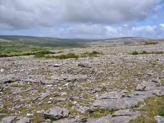
The Burren (from the Irish Boireann meaning ‘great rock’) is a region in County Clare in the
west of Ireland, covering approximately 250 square miles. It is composed of
limestone pavement with deep cracks called grikes. The separate rocks formed by
the criss-crossing of the grikes are known as clints, and support a wide
variety of plant life, ranging from Arctic to Mediterranean. There are also
some rare species of butterflies and moths.
The area is also rich in archaeological and historical
sites. There are more than 90 stone age tombs and portal dolmens, and several
ring forts dating from about 500AD.
Polnabrone dolmen is a portal tomb from the New Stone Age
(approximately 3,000BC), It consists of a 12 foot capstone, supported by 2
portal stone, about 6 feet high. The tomb chamber was excavated in the 1980s
and contained the remains of between 16 and 22 adults, and 6 children. Also in
the tomb were a polished stone axe,
a bone pendant, quartz crystals, weapons, and pottery. It’s thought the
dominating position of Poulnabrone on the Burren probably made it a centre for
ceremony or ritual until the Celtic period.
Caherconnell
stone fort dates from Celtic times (about 1500 years ago). Its position
overlooking the surrounding area suggests it was built for defence, not
necessarily military, but against raider and wild animals. It is circular,
about 140 feet in diameter, and the walls are about 12 feet thick. They consist
of stone blocks, many 3ft long and 2ft 6inches high. It is the best preserved
of all the ring forts on the Burren.
At the south
western edge of the Burren region are the Cliffs of Moher, rising to 700
feet above the Atlantic at their highest point. They are named after an old
fort called Moher which stood at the southernmost point of the cliffs. There
are an estimated 30,000 birds on the cliffs, including gulls, guillemots, and
Atlantic puffins.


